|
Introduction
The Upper Esopus Creek watershed covers a 192 mi2 area in the
South-central Catskill mountain region of southeast New York State.
The entire 26-mile course of the creek flows “clockwise”
in a sweeping arc from the headwaters at Winnisook Lake on Slide
Mountain to the Ashokan Reservoir.
Upper Esopus Creek and its tributary network drain some of the
most rugged terrain in the Catskill Mountains. There are 21 peaks
greater than 3000 feet above sea level (ft asl) that are drained
by this network. Among them is Slide Mountain, the highest peak
in the Catskills at 4,120 ft asl. The base elevation in the watershed
at Ashokan Reservoir is 633 ft asl. The resulting streams are
steep erosive forces as water and sediment make the quick descent
from mountain top to the base of the watershed at the reservoir.
The watershed includes at least 330 miles of stream.
Maps
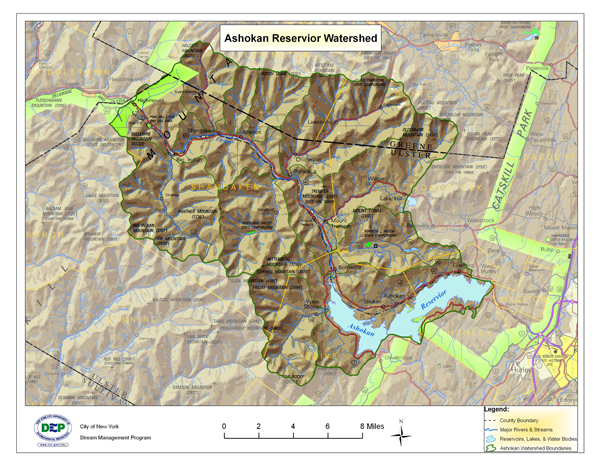
Click
here for a larger view of the above map
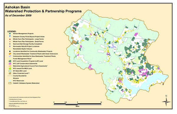
Click
here for a larger view of the above map
Click on the links below for more maps:
Bedrock
Geology
Glacial
Geology
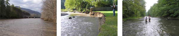
Bank
Erosion
Hemlock
Wooly Adelgid Locations
USGS Gage Links
The United States Geological Survey (USGS) maintains 11 continuous-recording
stream gages in the Esopus Creek watershed above the Reservoir.
These gages measure the stage, or height, of the water surface
at a specific location, updating the measurement every 15 minutes.
Click on the Station ID number of your gage of interest to receive
real-time water surface data from USGS.
| Station
ID |
Station
Name |
Drainage
Area (Mi_) |
Current
Period of Record |
| 01362200 |
Esopus Creek @ Allaben, NY |
63.7 |
Sep 1988 - present |
| 01362500 |
Esopus Creek at Coldbrook, NY |
192 |
Oct 1931 - present |
| 013621955 |
Birch Cr at Big Indian |
12.5 |
Oct 1998 - present |
| 01362230 |
Diversion From Schoharie Reservoir |
|
Dec 1996 - present |
| 0136230002 |
Woodland Creek above mouth at Phoenicia, NY |
20.57 |
Oct 2003 - present |
| 01362342 |
Hollow Tree Brook at Lanesville, NY |
1.95 |
Oct 1997 - present |
| 01362380 |
Stony Clove Creek nr Phoenicia, NY |
31.5 |
Feb 1997 - present |
| 01362497 |
Little Beaver Kill @ Beechford nr Mt. Tremper, NY |
16.5 |
Oct 1997 - present |
Demonstration Restoration Projects
Click
here for Esopus Creek Restoration Project Report
Click here for Esopus
Creek Project Power Point (file size 9.6 MB)
Stony Clove:
Click
here for Lanesville Demonstration Project
Stream Management Plans
Click
here for Intro and links to Stream Management Plans
Click
here for Watershed Overview
Click on the following links for more information:
Esopus
Creek
Stony
Clove
Broadstreet Hollow:
Broadstreet Hollow Restoration Project Implementation Report (2.2 Mb)
Broadstreet Hollow Restoration Project Monitoring Report (Appendix F of above report)(4.2 MB)
Ashokan Basin Action Plan(s)
Action Plan to Guide Stream Management Plan Implementation, 2009-2011
Action Plan to Guide Stream Management Plan Implementation, 2010-2012
Action Plan to Guide Stream Management Plan Implementation, 2011-2013
Action Plan to Guide Stream Management Plan Implementation, 2013-2015
Ashokan Basin Stream Management Plan Implementation Funding
Mini Grant Program - The mini grant provides up to $5000 for education, training, community programs, small projects etc. in the Ashokan Watershed. Click here for application materials.
Matching Grant Program - The matching grant provides up to $100,000 or 25% of the cost of a project (whatever is less) to either match a grant or enhance a funded project that helps to implement stream management program recommendations. Eligible categories are research, community projects, training and education, and stream projects. Click here for application materials.
Basin Specific Studies and Publications
Click here for Glacial
Geology Description
Guide to Stream Friendly Practices for Common Streamside Projects
Contact Information
Click on the following links for more information:
For information on the Upper Esopus Creek Stream Management Project,
coordinated by Cornell Cooperative Extension of Ulster County
Zen Environmental Studies Institute, Mount Tremper, NY
Ulster County Soil and Water Conservation District |