Section 1
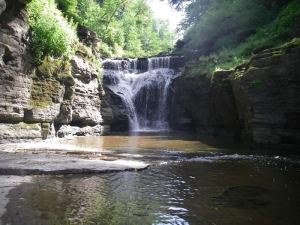 Table of Contents, Preface and Acknowledgements
Introduction & Goals
Section 2 – Manor Kill Natural and Institutional Resources (Complete Section – (5.7 MB))
This section provides watershed background information and characteristics which influence the Manor Kill. A chapter on living streamside and stream related activities may be of particular interest to landowners, answering commonly asked questions, including necessary permits and agency contacts, relating to activities which may impact stream health or stability.
2.1 Regional Setting
2.2 Watershed History
2.3 Physical Geography
2.4 Hydrology and Flood History
2.5 Watershed Geology
2.6 Wetlands & Floodplains
2.7 Riparian Vegetation (2.4 MB)
2.8 Landuse/Landcover
2.9 Fisheries & Wildlife (1.2 MB)
2.10 Recreational Opportunities
2.11 Stakeholders
2.12 Agency Contacts and Program Resources
2.13 Permit Requirements
Section 3 – Watershed Inventory and Assessment (Complete Section (1.2 MB))
This section includes a summary of water quality assessments that have been undertaken over the years in the Schoharie Creek and Manor Kill, an introduction to the science of stream processes, and a description of the watershed assessment protocol used to develop this stream management plan.
3.1 Water Quality Assessment
3.2 Introduction to Stream Processes
3.3 Watershed Inventory & Assessment
Section 4 – Management Unit Descriptions
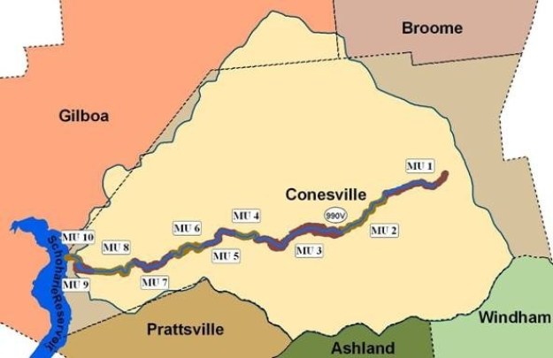
This section contains very detailed descriptions and specific recommendations for the Manor Kill, from the headwaters at the top of the watershed, downstream to its confluence with Schoharie Reservoir, located in the Town of Conesville. The Manor Kill mainstem has been organized into 10 Management Units (MUs), defined using physical stream characteristics, historical channel alignments, location of bridges and road infrastructure, and valley characteristics (Fig. 4.0.1). These MU descriptions outline stream conditions (its bed and banks), general streamside (riparian) vegetation condition, and proximity and arrangement of roads, bridges and culverts.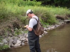
Introduction
Management Unit 1 (891 KB)
Management Unit 2 (2.7 MB)
Management Unit 3 ( 1.5 MB)
Management Unit 4 ( 1.7 MB)
Management Unit 5 ( 858 KB)
Management Unit 6 ( 2.4 MB)
Management Unit 7 ( 2.7 MB)
Management Unit 8 (1.8 MB)
Management Unit 9 (1.4 MB)
Management Unit 10 (1.3 MB)
Section 5 – General Recommendations
This section sets forth an extensive list of recommendations related to education and outreach, flood protection, water quality, public enjoyment, fisheries, riparian zone management, stream management, and programmatic issues, providing a frame work for watershed stakeholders to develop a long term management strategy to protect and improve the Manor Kill.
Appendices
Appendix A Native Vegetation
Appendix B Vegetation Mapping Protocol
Appendix C Complete Biodiversity Table
Appendix D Shandaken SPDES Permit
Appendix E Stream Management Data Dictionary Guide
Appendix F Fish and Macroinvertebrate Survey Reports (SUNY Cobleskill)
Glossary
Manor Kill Management Plan Project Team
| Greene County Soil & Water Conservation District 907 County Office Building Cairo NY 12514 Phone 518-622-3620 Fax 518-622-0344 Abbe Martin, Manor Kill SMP Project Manager abbe@gcswcd.com |
Schoharie County Soil & Water Conservation District 173 South Grand Street Cobleskill NY 12043 Phone 518-234-4092 Fax 518-234-4093 Peter Nichols, Stream Program Manager Peter.Nichols@schohariesoilandwater.org |
| Schoharie County Planning & Development 349 Mineral Springs Road Cobleskill, NY 12043 Phone 518-234-3751 Fax 518-234-3951 Alicia Terry, Director of Planning |
NYCDEP Stream Management Program 71 Smith Ave Kingston NY 124021 Phone 845-340-7850 Fax 845-338-1367 David Burns, Project Manager dburns@dep.nyc.gov |