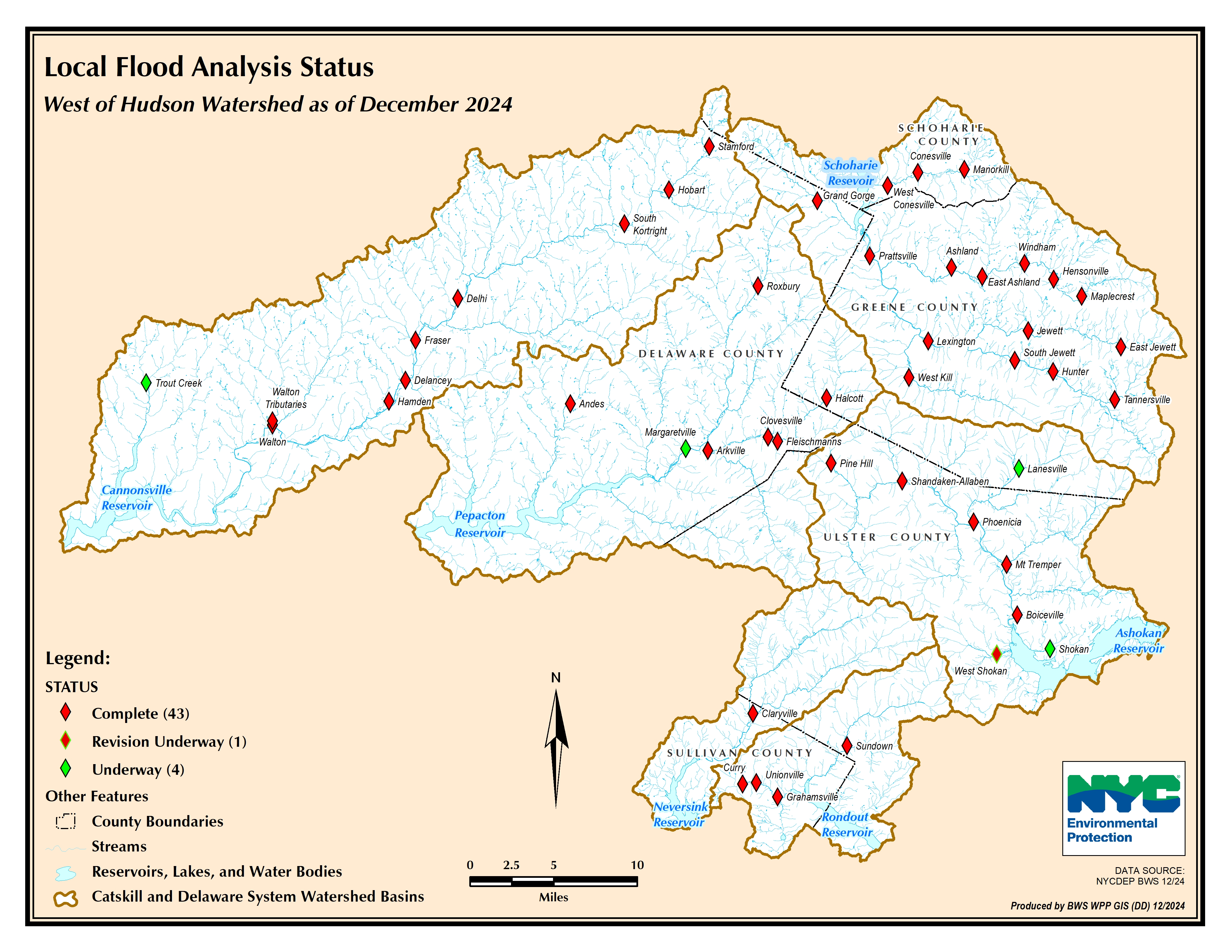
Following Tropical Storms Irene and Lee in 2011, a framework was developed for funding flood hazard mitigation in the NYC West of Hudson watersheds. It has been recognized that flooding produces a variety of hazards and impacts not only to public safety, but also to water quality. Under this new initiative, Stream Management Programs in the NYC water supply watersheds and the Catskill Watershed Corporation are supporting the analysis of flood conditions and the identification of hazard mitigation projects. The process consists of two steps: 1) an engineering analysis of flood conditions and identification of potential flood mitigation projects articulated in a plan and 2) project design and implementation. The engineering analysis and plan are termed “Local Flood Analysis.” The LFA Program Rules define the process for municipalities to apply for funding to complete a Local Flood Analysis (LFA). The program rules also define the process for municipalities to seek funding from the Stream Management Program to implement projects that involve streams, floodplains and adjacent infrastructure to reduce flood hazards.
Completed LFA Study Area(s), Stream(s) and Date:
East Branch Delaware River (Pepacton):
Arkville (East Branch Delaware River, Dry Brook, Bush Kill) – 2017
Andes (Tremper Kill, Liddle Brook) – 2018
Halcott (Vly, Brownell, and Elk Creeks) – 2019
Roxbury / Grand Gorge (East Branch Delaware River) – 2021
West Branch Delaware River Watershed (Cannonsville):
Village of Walton (West Branch Delaware River) – 2015
Walton Tributaries (East, West, and Third Brooks) – 2017
Hamden / Delancey (West Branch Delaware River) – 2017
Stamford / Hobart / South Kortright (West Branch Delaware River, Town and Grant Brooks) – 2021
Esopus Creek Watershed (Ashokan):
Phoenicia / Mt. Tremper (Esopus and Stony Clove Creeks, Beaver Kill) – 2016
Boiceville / West Shokan (Esopus Creek, Bushkill) – 2017
Shandaken / Allaben (Esopus and Bushnellsville Creeks) – 2018
Pine Hill (Birch and Alton Creeks) – 2022
Lanesville (Stony Clove Creek) – 2025
Neversink River Watershed (Neversink):
Claryville / Denning (East Branch Neversink and Neversink Rivers) – 2016
Grahamsville / Unionville / Curry (Chestnut Creek) – 2022
Rondout Creek Watershed (Rondout):
Sundown (Rondout and Sundown Creeks) – 2016
Schoharie Creek Watershed (Schoharie):
Prattsville (Schoharie and Huntersfield Creeks) – 2013
Windham / Hensonville / Maplecrest (Batavia Kill) – 2015
Lexington / West Kill (Schoharie Creek, West Kill) – 2016
Conesville / West Conesville / Manorkill (Manor Kill) – 2017
Tannersville (Gooseberry and Sawmill Creeks, Allen Brook and tributary) – 2018
Hunter (Schoharie and Shanty Hollow Creeks, Mad Brook) – 2018